This week, BITS Participants are walking the Benjamin Franklin Parkway with digital cameras and clipboards in hand. They are examining three aspects of this iconic Philadelphia landscape. First, they are searching for unexpected features, unique historical and cultural juxtapositions, signs of competing uses, and the use of symbols to represent Philadelphia's urban identity and history. Second, the BITS team is examining the design and environmental characteristics of the Parkway. Finally, they are assessing the relationship between the pedestrian and transportation modalities of the space.
Here are links to institutions and organizations we encountered along the way.
Schulkill Banks
Center City and Fairmount are connected via a new, paved path for pedestrians, cyclist, wheelchair, stroller, and roller use.
The Water Works
The Delaware River Basin includes the watersheds of the Wissahickon Creek, the Schulkill River and the Delaware River. This educational center is a resource for learning about the historical development and contemporary challenges of those waterways.
Logan Square Neighborhood Association
"The square is a circle." This comment has been echoed at the foot of the Swann Fountain. Check out the LSNA's history page here.
Sadie's First Walk
Here is a map of the walk route, updated regularly to add new photos and links of interested based on our visits.
Click Here to read our prior post on the Parkway walk and associated Resource Links.
Michele Masucci, Director
ITSRG - Temple University
|
0 Comments
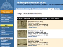 www.philadelphiabuildings.org Tomorrow, BITS Interns and Service Learners will walk the Ben Franklin Parkway as part of their respective examinations of historic landscapes and green spaces in Philadelphia. Interns are creating a virtual reality that includes various digital media to depict the iconic planned city park system from a contemporary perspective. Service Learners are examining green spaces throughout the Fairmount Park system and in the city. They will analyze the different uses and users of the park spaces and document the different types of green spaces incorporated in the park system. Their observations will be drawn upon to create designs for new trails, marking existing trails, and mapping routes that the general public can use within the park system, including both Fairmount Park and Wissahickon Park venues. 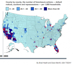 Hardly a day goes by without the announcement of a new dire circumstance for local economies. The stories include layoffs, hidden effects of the economic downturn, growing pockets where local effects are visible, and fewer opportunities and services for citizens to maintain their quality of life. On behalf of the Information Technology and Society Research Group of Temple University, we wish to express sincere thanks to the geo-blogging community for following ITSpace during the past six weeks as we have called attention to growing trend for citizens to share spatial information using web 2.0 applications. In particular, we wish to give a special thanks to the folks at Very Spatial for calling our series to the attention of their readers and pod cast audience. We are grateful for the insightful comments shared by the professional geographers across the country and members of online map user communities. Thank you also for the contributions of guest authors David Organ and Paul Schroeder. We will continue to welcome guest authors to post new discussions, so please do not hesitate to contact us about new post ideas related to the theme of Citizen Cartographers in the future. BITS Summer Program 2008 is underway throughout the month of July. This year we are providing students with research and field experiences and information technology skills in mapping historic markers related to the African American experience in Philadelphia. 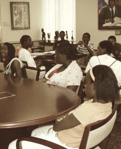 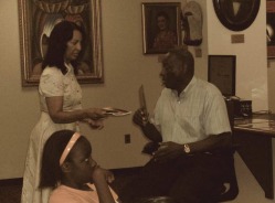 This summer, our students are focused on creating web-interactive maps of the entire marker collection documented by Dr. Blockson. Dr. Blockson has spent a great deal of time helping our students to understand the politics of marking by sharing some of the stories related to how and why specific settings are ultimately chosen to receive an official state historical marker. They have found that there is no single consolidated listing of markers, since more than one institution has programs to place markers at historical sites. And, since the various marker programs do not create meta-tags denoting categories for inclusion, it is difficult to search for maps of markers online. Here is the map one of our students, Hazreena Ali, has created drawing from Mr. Blockson's book detailing sites related to African American history designated by the State of Pennsylvania to be of interest within Philadelphia. One interesting example of a setting that has been given a state historic marker is the Legendary Blue Horizon, located on North Broad Street, just a few blocks from Temple University's Main Campus. Many of the greatest boxers of the last century have fought and trained at the Blue Horizon. Surprisingly little information about it is found online, and even less is noted on the marker outside. Our approach for providing students with an understanding of its historical and cultural significance within the African American community of Philadelphia and beyond has been to visit, photo-document, and map the location during the past four years. Through this process, our students have come to understand that it is a living legacy that continues to host world-renowned boxing events, and that its owners are striving to compile archives of its historical significance and share them with the public. Newspaper clippings are framed behind the venue manager's desk, shown here in a photo taken by students in the BITS Program during the summer of 2006. Over the past year, various Web 2.0 technology platforms have begun to provide its users with the ability to connect content they have created with a location, thus enabling not only keyword searches but location-based searches. This experience has been further enhanced through geoRSS feeds and geotags which integrate technologies such as Twitter and Flickr with online mapping sites such as Google and Yahoo Maps. Thanks to Temple's IT and Society Research Group (ITSRG) for creating a space for "citizen cartographers" to show their work. I hope this opportunity continues beyond June into the coming months. 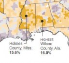 Gas Maps Part 2 examines a map published by The New York Times on June 9th, 2008 called "The Varying Impact of Gas Prices" that has been in heavy Internet circulation during the past week. It shows the locations where consumers spend the highest percentage of their income on gasoline. In general, poor rural counties in the Southeast and Appalachia; along the Mississippi River; in Texas, Oklahoma and New Mexico and in the Northern Rocky Mountains states are fairing the worst despite the fact that urban centers on both coasts have higher per gallon costs. The place that earned the dubious distinction of the highest gasoline costs as a percent of income is Wilcox County, Alabama. There, residents pay on average 16% of their income on gas at current prices. The rest of the counties in the Black Belt along the Alabama River share a similar impact.  Gee's Bend once served as a safe haven in the racially tumultuous environs of west Alabama for Dr. Martin Luther King, Jr. and other local and regional civil rights activists to reside and organize prior to the historic march for voting rights from Selma to Montgomery in 1965. Their struggles and efforts are embedded in the memories of the people and local institutions of Wilcox County and Gee's Bend. Forty three years later, we are reminded that regional and economic disparities and institutionalized forms of racial inequality persist in the social landscape of American society.  Soaring gasoline costs have prompted keen consumer interest in finding the locations of service stations that have the lowest prices per gallon. The problem is an interesting one from a geographic perspective. The key to saving money is to find the lowest cost source of gasoline that is located as close as possible to a person's normal driving rounds. This allows the consumer to maximize savings by minimizing the cost of driving extra distances to search for cheap gas. Web maps have proliferated to fill in local knowledge of where gasoline is cheapest just-in-time for a fuel-up. 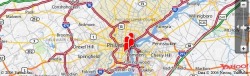 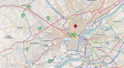 Openstreetmap.org and Wikimapia.org are two wiki-enabled collaborative mapping applications that support web user defined geographic content anchored to a common global geo-coordinate system. (ITSRG is among the handful of collaborators for the Philadelphia region, shown in the map above.) Wikimapia - Temple Town, North PhiladelphiaE-Pumpkin Carve Google Maps Mash Up
View Larger Map |
ITSpace: Geographies  Flickr BITSArchives
November 2011

BlogrollBest Green Blogs Categories
All
|
 RSS Feed
